
You can’t prove a negative from space. That sentence is the whole of it, and most vendors won’t say it to you.
A satellite check can tell you that no deforestation was detected on a plot after the cut-off. It cannot tell you that none occurred. Cloud cover, canopy shadow, gradual thinning, a plot smaller than the imagery resolves — all of these produce the same clean-looking answer as land that genuinely never changed.
So the question worth asking a compliance vendor isn’t “is your detection accurate?”. It’s “what does your record show when the answer is uncertain?” Because under Regulation (EU) 2023/1115 it’s you who signs the due diligence statement, and it’s you who has to stand behind it.
We don’t detect deforestation. FAO does.
Let’s be direct about this, because it matters more than a marketing claim would.
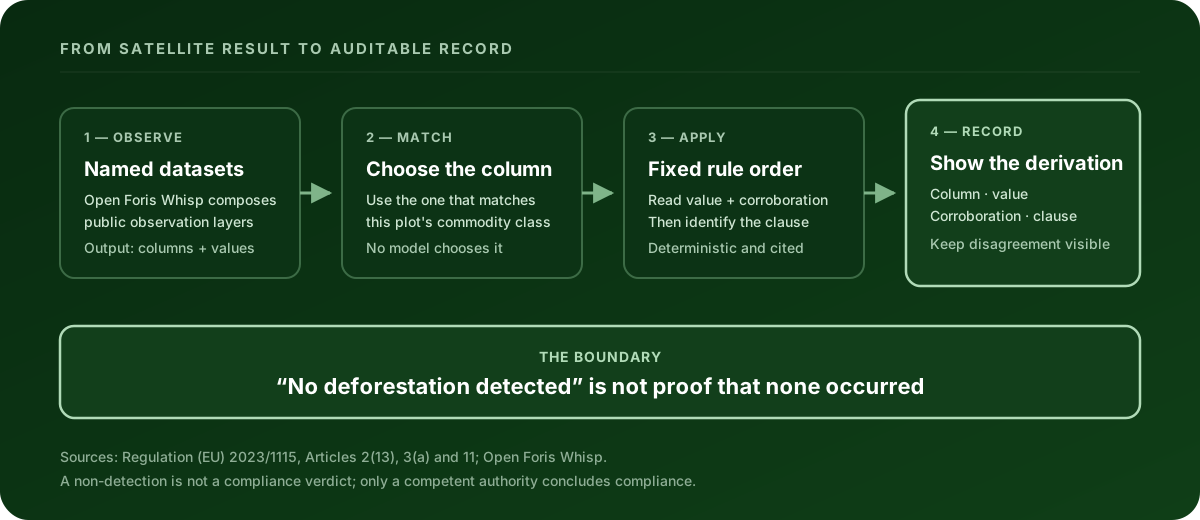
Clearlane computes no deforestation figure of its own. The detection comes from Open Foris Whisp, an open-source tool from FAO and the Forest Data Partnership. It composes established Earth-observation datasets and publishes risk columns.
Those datasets are public and named:
| Dataset | Who publishes it |
|---|---|
| Global Forest Cover 2020 | EC Joint Research Centre |
| Global Forest Change | Hansen / University of Maryland |
| Tropical Moist Forest | EC Joint Research Centre |
| RADD radar disturbance alerts | Wageningen University |
| GLAD disturbance alerts | University of Maryland |
| WorldCover | European Space Agency |
You will find these names printed in the evidence report itself. Two of them are CC-BY licensed, so crediting them is a licence condition, not a courtesy — a report that hides its sources is breaching the terms it relies on.
Anyone telling you their deforestation detection is proprietary is either using these same public layers, or asking you to trust an unpublished model with a legal filing. Neither is a selling point.
Then what are you paying for?
What happens after the satellite answer arrives.
An Earth-observation result is a set of columns and values. Turning that into something an auditor accepts means answering four questions, and none of them are about imagery:
- Which column actually answers the legal question for this plot? A cocoa plot and a timber plot are asking different things. Reading the wrong column produces a confident, wrong answer.
- What did that column say, in words a person can check?
- Which rule then fired, and in what order of precedence?
- What happens when the answer is undecided?
Most of the work — and all of the risk — lives in question four.
The rule we apply, and the part that matters
The engine reads the column that matches the plot’s commodity class, then applies a published rule in a fixed precedence order. In plain terms:
- Risk found → the plot is flagged. Article 3(a) admits a product to the market only if it is deforestation-free, and nothing in our product overrides that.
- Low risk → recorded as “no deforestation after 31 December 2020 was detected” — and the record says, in those words, that this is not the same as proof that none occurred.
- Undecided, with corroboration that nothing was disturbed → treated as a trigger to ask for further evidence under Article 11, not as a pass.
- Anything else — column missing, unreadable, or undecided without that corroboration → stops at no readable result.
No readable result is never a pass. It is never shown as green. If we cannot choose the right column for a plot at all, the rule deliberately over-flags rather than risk clearing something it shouldn’t.
That last sentence is the design principle underneath all of it: the system is built to be wrong in the safe direction. A false flag costs you an afternoon. A false clear costs you the filing you put your name on.
The 31 December 2020 cut-off is Article 2(13). We never retype it — it’s read from a single versioned file that carries its citation, so it cannot drift out of step between the engine, the report and this page.
What the record has to show
Here’s the test worth applying to any vendor, ours included.
In July our founder walked through his own product and said: “I’m just trusting this. I want to see what it did to tell it’s deforestation-free — and why it thinks it’s not.”
The report showed the verdict. It showed the measurements. It did not show the step between them. So we built that: which column was read, what value it held, which corroborating figure the rule needed, and which clause therefore fired.
Three things follow from that, and they’re the ones we’d want you to check:
The explanation cannot drift from the engine. The plain-English derivation and the engine’s own logic are run against every possible combination of inputs in the test suite, and the build fails if they ever disagree. An explanation that quietly stops matching the code is worse than none, because it reads as verification.
When the data disagrees with the verdict, the report says so. If the stored values don’t account for the recorded outcome, that divergence is printed rather than smoothed over. An auditor is entitled to it, and papering over it would be the one genuinely dishonest option available.
No model decides anything. AI is used to read and explain documents. Every compliance outcome comes from the deterministic engine, from versioned rules with citations. A language model’s opinion is not evidence, and it has no place in a legal filing.
What this cannot do for you
Being clear about the boundary is part of the product.
- It does not make you compliant. Only a competent authority concludes that.
- A non-detection is not proof of absence, and the report never claims otherwise.
- We prepare and validate your evidence and hand it back to you. We never file to TRACES or any registry on your behalf.
- Where we haven’t verified a dataset’s licence terms against a primary source, the report says the licence is unestablished — it does not claim the data is free to reuse. An earlier version of our own report printed “free reuse” for five datasets on nobody’s authority. We fixed it, because asserting in print that no condition exists is worse than the gap it replaced.
Where to start
If you have plot data now, the useful first move isn’t a satellite check — it’s finding out whether your geometry is even valid, because a rejected file never reaches the analysis at all.
Validate your plot data free — it tells you exactly what fails and where, with no account.
Related reading: what the EUDR requires, the geolocation rules, and the risk assessment step.
Sources
- Regulation (EU) 2023/1115, consolidated 26 December 2025 — Articles 2(13), 3(a), 11
- Open Foris Whisp and the Whisp repository — the detection provider and its dataset documentation
This article explains how our evidence is produced. It is not legal advice, and your competent authority is the authority on your specific case.