
Under the EUDR, a plot of land larger than four hectares that produces anything other than cattle has to be described with a polygon — a boundary with enough latitude and longitude points to trace its perimeter. A plot of four hectares or less can be a single latitude and longitude point, and a polygon is fine there too. An establishment where cattle were kept can be a single point whatever its size.
That is the whole rule, and it fits in three lines. The hard part is deciding which of your production places it applies to — and what the file says about a plot whose size nobody wrote down.
What the four-hectare rule actually says
The threshold lives inside a definition, not in an obligation, which is part of why people miss it. Article 2, point (28) of Regulation (EU) 2023/1115 (EUDR) defines geolocation as:
“the geographical location of a plot of land described by means of latitude and longitude coordinates corresponding to at least one latitude and one longitude point and using at least six decimal digits; for plots of land of more than four hectares used for the production of the relevant commodities other than cattle, this shall be provided using polygons with sufficient latitude and longitude points to describe the perimeter of each plot of land”
Two numbers do all the work: six decimal digits of precision, and four hectares. Everything below is a consequence of one of them.
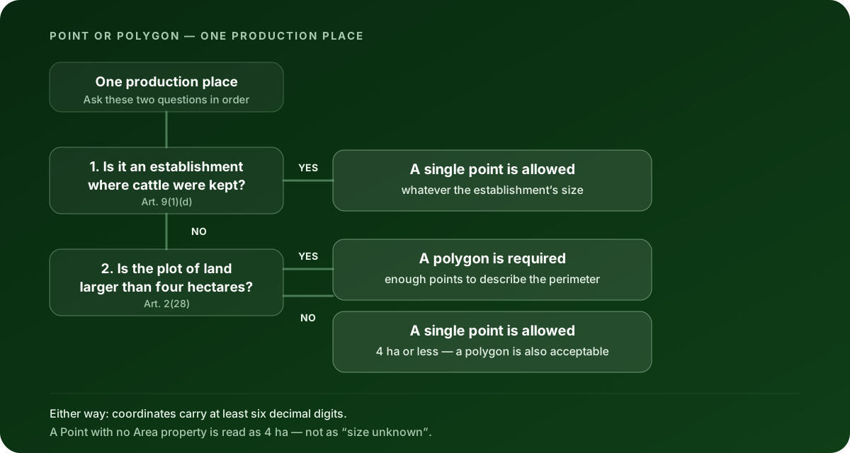
Point or polygon: the decision in one table
| Your production place | What the geometry has to be |
|---|---|
| Plot of four hectares or less, not cattle | A single latitude/longitude point — or a polygon, if you have one |
| Plot larger than four hectares, not cattle | A polygon with enough points to describe the perimeter |
| Establishment where cattle were kept | A single point, whatever its size — or a polygon |
| Size genuinely unknown, not cattle | Treat it as a polygon job. See the Area trap below |
A polygon is never wrong. That is worth holding on to, because it turns a judgement call into a default: if you are unsure which row you are in, the boundary satisfies every row.
What counts as “a plot of land”?
This is where the threshold gets misread most often, and it is not a small misreading — it decides whether one farm is one geometry or thirty.
Article 2, point (27) of Regulation (EU) 2023/1115 (EUDR) defines a plot of land as “land within a single real-estate property, as recognised by the law of the country of production, which enjoys sufficiently homogeneous conditions to allow an evaluation of the aggregate level of risk of deforestation and forest degradation associated with relevant commodities produced on that land”.
Read that against the four-hectare threshold and two things follow.
The threshold is per plot, not per farm, per supplier or per shipment. A cooperative with 400 members does not have one 900-hectare production place; it has 400-odd plots, each of which gets measured against four hectares on its own. Aggregating them into one big boundary is not a shortcut — it describes land nobody produced on.
And the definition is anchored to the law of the country of production, not to how your ERP groups things. A single real-estate property under Ivorian or Indonesian law is the unit, whatever your purchase orders call it.
Article 9(1)(d) of Regulation (EU) 2023/1115 (EUDR) then asks for the geolocation of all of those plots for the products you place on the market, together with the date or time range of production.
Is exactly four hectares a point or a polygon?
A point. The text says “more than four hectares”, so the test is larger than, not at least. A production place measured at exactly 4.0 hectares sits on the permitted side of the line.
Do not build a supply chain on that, though. Four hectares measured off a hand-held GPS walk, a cadastral record and a satellite trace will rarely agree to the second decimal, and the one that matters is the one in your file. When a plot lands anywhere near the hinge, the boundary removes the argument entirely.
A point with no Area is not “size unknown”
Here is the trap, and it catches careful people.
The European Commission’s EUDR GeoJSON File Description v1.5 — the file format linked from the EUDR Information System page — gives a Point feature an optional Area property, in hectares. When that property is absent, the point does not mean “we didn’t measure it”. It is read as four hectares.
So an unsized point is not a blank. It is a claim. If the plot behind it is nine hectares, the file is quietly saying something untrue about a real piece of land, and it will pass a naive structural check while it does so.
Two more numbers sit around that property, both from the EUDR Operator API Reference v1.0 for API V3: the current V3 reference sets a minimum Point Area of 0.0001 hectares, and where the property is present it has to be a positive number. Values between 0.0001 and 0.1 hectares are worth a second look rather than a shrug — the older EUDR Validation Rules v1.3 stated a 0.1 ha floor, and the two documents disagree.
If you have a file in front of you, you can settle this in about a minute. Clearlane’s free EUDR GeoJSON validator and repair tool runs the cited rule profile in your browser, flags every point that trips the four-hectare rules (over the maximum, under the minimum, in the review band), and plots the whole file on a map so an obviously wrong geometry becomes obvious. The file never leaves your browser and there is no account to make.
How narrow is the cattle exception?
Narrower than the shorthand “cattle are exempt” suggests, and it is an exception about what you point at, not about precision.
Article 9(1)(d) of Regulation (EU) 2023/1115 (EUDR) puts it this way: “for relevant products that contain or have been made using cattle, and for such relevant products that have been fed with relevant products, the geolocation shall refer to all the establishments where the cattle were kept; for all other relevant products of Annex I, the geolocation shall refer to the plots of land”.
An establishment, defined at Article 2, point (29), is “any premises, structure, or, in the case of open-air farming, any environment or place, where livestock are kept, on a temporary or permanent basis”.
Three things follow from those two sentences. The unit for cattle is the establishment, so a 600-hectare ranch is a place you can name with one coordinate. It is all the establishments where the animals were kept, so a herd that moved seasonally produces several points, not one. And “on a temporary or permanent basis” means a holding site counts.
The exception does not travel to the rest of your Annex I commodities. Coffee, cocoa, soy, palm oil, rubber and wood are back to plots and the four-hectare test — including on a mixed farm that also keeps cattle.
Does a polygon cost you anything?
Effort, yes. File size, a little — and there is one documented ceiling worth knowing before you convert an entire supplier base to boundaries.
The Commission’s May 2026 Operator API V3 reference caps the geolocation data in an assembled declaration at 25,000,000 bytes, alongside limits of 1,000 producers per commodity and 10,000 producers per declaration. A polygon with 200 vertices is roughly two orders of magnitude heavier than a point. If you are consolidating thousands of smallholder plots into one submission, that ceiling is the constraint you will meet first, and it is a reason to keep vertex counts sane — not a reason to downgrade a large plot to a point.
What a correct geometry still doesn’t prove
Getting the four-hectare rule right is a data-quality result. It is not a compliance verdict, and the relief of a clean file is exactly when that gets forgotten.
A file with the right geometry does not mean the EUDR Information System has accepted a declaration. It does not show that the goods are deforestation-free, or that they were produced in accordance with the relevant legislation of the country of production. Under Article 3 of Regulation (EU) 2023/1115 (EUDR), all three conditions have to hold together: deforestation-free, legally produced, and covered by a due diligence statement or a simplified declaration (Art. 3(c), Regulation (EU) 2023/1115 as amended by Regulation (EU) 2025/2650, consolidation 02023R1115-20251226). Geometry is the first step of one of them.
Satellite and remote-sensing evidence sits in the same category. It can support a risk assessment and flag a change that deserves a closer look. On its own it does not show that goods are deforestation-free, legally produced or correctly linked to your supply chain.
The operator stays responsible for the full due diligence assessment and for the statement submitted to the authority.
Check the geometry before the file reaches the portal
If your plots are already in a file, run it through the free EUDR GeoJSON validator and repair tool — every rule quoted here has its own page in the error catalogue with the source it comes from. If you are still deciding what to collect, the shape of the answer is simple: boundaries for anything that could be over four hectares, points for the small plots and the cattle establishments, six decimals throughout.
For the wider set of checks a file has to pass, see what each EUDR GeoJSON validation error means. For the rest of what geolocation involves — precision, file structure, the errors that come up most — see when to use a point or a polygon.
Clearlane prepares and validates the data. It does not file to the EUDR Information System or any registry on your behalf.
This article is educational guidance, not legal advice or a compliance verdict.